|
|
AIT POLLUTION IN THE CZECH REPUBLIC IN 2000 Czech Hydrometeorological Institute - Air Quality Protection Division |
|
|
|
|
2.3.8 Air Quality Summary Assessment
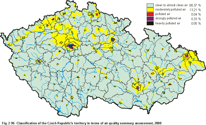
The preceding parts of this publication contain air pollution assessment for each of the pollutants or groups of related substances. Whenever the monitoring networks density allows, the regularly conducted annual assessments emphasise the mapping of regional distribution, particularly in respect to those pollutants and annual ambient air pollution characteristics for which the respective limit values have been laid down in Federal Committee for the Environments Decree attached to Act No. 309/1991 as mentioned earlier in the yearbook (i.e. limits on annual arithmetic mean concentrations of SO2, SPM, NOx, Pb and Cd in SPM, and the highest frequency at which SO2, SPM and NOx daily concentrations may be exceeded per year). In addition to the practical requirement to identify the areas where the limit values are exceeded regularly, for the purposes of aligning remedial measures with the EU Framework Directive 96/62/EC, the primary objective of mapping ambient air pollution levels regional distribution is to extrapolate site (point) measurements also to areas beyond the reading sites. Ambient air pollution levels regional distribution is analysed using geostatistical approaches such as the kriging method, IDW method (interpolation with weightings indirectly proportional to distance), and other methods supported by the GIS software. It is relatively complicated to describe air pollution by listing the levels of ambient air pollution characteristics for substances measured at a particular site, and their values relative to air pollution limits; this would also depend on the range of substances monitored on a given site. The efforts to substitute such a complicated description of air quality situation in a locality by an explicative, best of all verbally expressed classification have resulted in variously constructed air quality indices [5, 6]. When designing an air quality index the generally measured ambient air pollution levels are standardised using the air quality limits values prescribed and, being dimensionless numbers, levels of individual substances standardised in this way are combined. The values generated are then allocated to classification levels. Such constructions usually face a pitfall in that the application of mathematical operations in fact leads to the implementation of the new, legally void limit values being determined for the substances under review. The map in Fig. 2-96 represents summary air quality assessment for the year 2000 taking into account the ambient air pollution limit values set by the legislation. In its compilation, fields of each pollutants regional distributions were used and analysed by means of map algebra based on the classification listed in Table 2-82. In accordance with the legislative requirements the inputs to summary assessment specifically include: fields of annual arithmetic mean
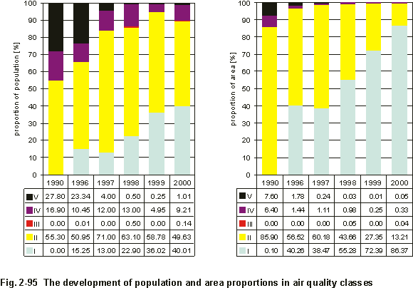
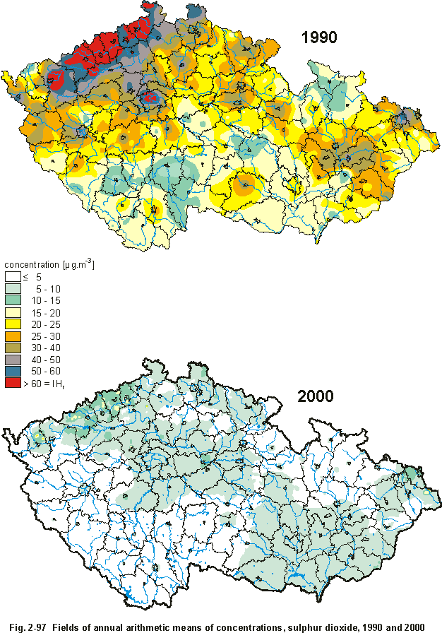
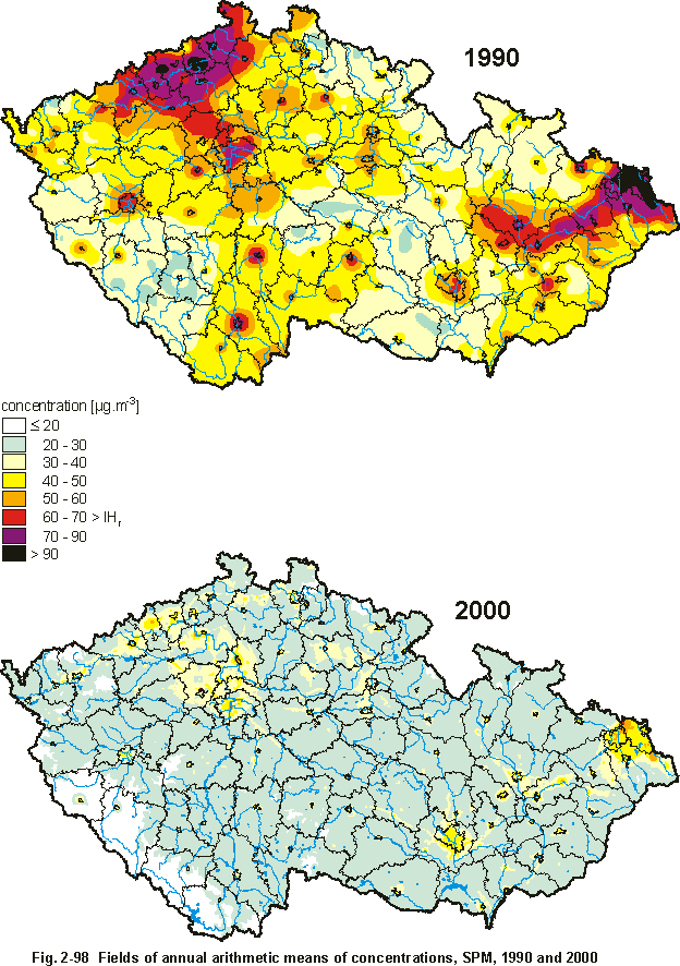
concentrations of fields of 95th percentiles of daily concentrations of In comparison with the preceding years, when exceedences of mainly SO2 and SPM level values were dominant, after 1998 classification of the polluted to heavily polluted classes is characterized almost exclusively by frequency of exceedence of NOx daily limit values resulting from the ever increasing road transport. However, it is necessary to point out that the presented assessment is based on the current limit values. With the adoption of the new legislative documents on air quality in compliance with the European Directives and the respective limit values covered by them, the picture of the presented assessment will be fundamentally changed. As results from the preliminary assessment carried out with regard to the EU Directives [14] the decisive problem arises with the exceedance of PM10 limit values. Graphs in Fig. 2-95 show the development of population and area proportions in the stated air quality classes (% of the total population and territory of the Czech Republic). The graphs demonstrate a visible increase in classes I and II and a decrease in classes III to V. The graph in Fig. 2-95 shows that this positive trend broke or slightly deteriorated after 1999. Table 2-83 lists settlements with populations over 3,000, located in areas of polluted to heavily polluted air (class III to V). In contrary to 1996 year a noticeable decrease in amount of municipalities, from 47 to 8, included in classes of polluted to heavily polluted air quality (according to the classification shown in Table 2-82) was recorded in 1999. Table 2-83, on the contrary, shows that in 2000 the number of settlements in the above classes slightly increased to 15. Significant decrease of air pollution levels of practically all above pollutants, especially in the years 1997â1999, confirms the expected development in connection with the term of entry into force of emission limit values for pollutants. The improvement of the recent air pollution situation in comparison with the early 90s, is illustrated on maps of annual average concentrations of sulphur dioxide and SPM in 1990 and 2000 (Fig. 2-97 and 2-98). Tab. 2-82 Regional classification of ambient air quality
Tab. 2-83 Settlements with population over 3,000 in zones of ambient air quality classes No. III to No. V, 2000
|