
Distributed Modeling

A truly distributed modeling approach is one that represents processes via high-resolution, distinct model elements. This can be performed in a gridded manner, or through smaller sub-basins, flowplanes, triangulated irregular networks, or hydrologic response units. This approach provides for detailed predictions at many points across a basin. For simplicity, we will examine the distributed modeling concept with the grid-cell approach here.
With this type of approach, each cell has parameters allowing for its own streamflow estimates. The flow at any grid point can be estimated mathematically. One drawback to distributed modeling is the additional input data required for each cell. If these data are not available, they must somehow be estimated, introducing an uncertainty factor.
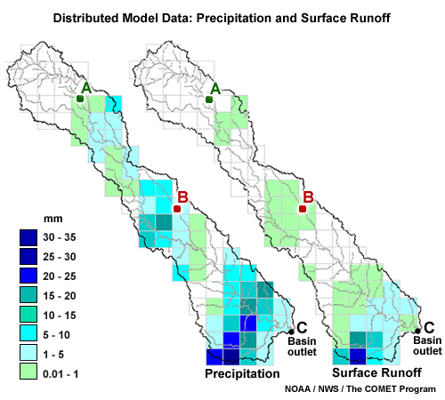
Above, we have gridded precipitation and surface runoff data for a basin. Very little rain fell on the upper part of the basin. There is no runoff response at point A. Small amounts of rain fell in the middle of the basin, so the runoff does show a small response at point B.
The heaviest rain fell in the lower part of the basin resulting in a significant and rapid peak flow at point C.
A lumped simulation for this basin would only show the averaged effects over the whole basin. It would underestimate the peak amount for point C, and the timing at point C would be inaccurately delayed.
The distributed model, however, is able to capture the spatial variability of the precipitation and produce a more reasonable simulation at point C as well as flow estimates at points A and B.
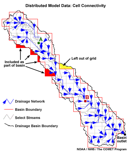
In this image we see the downstream flow vectors for each cell. Physics-based parameters and equations are used to route flows from cell to cell to the outlet.
Keep in mind that this represents an estimate of the flow path. We see that some parts of the basin are left out in the conversion to the grid representation. At the same time, other areas that actually lie outside of the basin are included in the gridded area.
The former Danish Hydraulic Institute, an international non-profit consulting group operating as DHI, has developed a suite of models that simulate many hydrologic processes, depending on need. MIKE 11, the rainfall-runoff model, may be run at several stages of complexity, depending on need and available data. It may be run in a lumped mode that simulates only overland, inter- and base flows or it may be run up to a fully-distributed mode that simulates runoff, hydrologically and hydraulically routed streamflows and other processes such as river-aquifer exchange. There are intermediate rainfall-runoff modes which include an event-based package, as well as a soil moisture accounting mode and a semi-distributed mode. These and various other water modeling resources from DHI are popular around the globe in both research and operational forecasting efforts. For more information, please see DHI’s website: http://www.mikebydhi.com
Distributed hydrologic models are becoming more popular and spatially complex as technologies such as Doppler radar, Global Positioning System (GPS), and Geographic Information Systems (GIS) are becoming more widespread in the creation of geo-referenced, gridded datasets.