|
|
AIR POLLUTION IN THE CZECH REPUBLIC IN 2008 Czech Hydrometeorological Institute - Air Quality Protection Division |
|
|
|
|
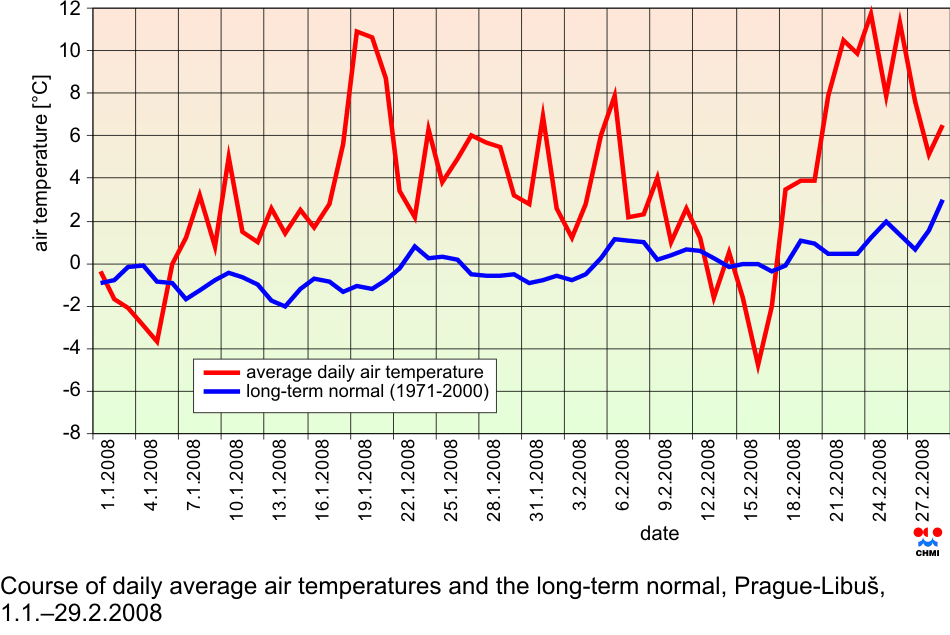
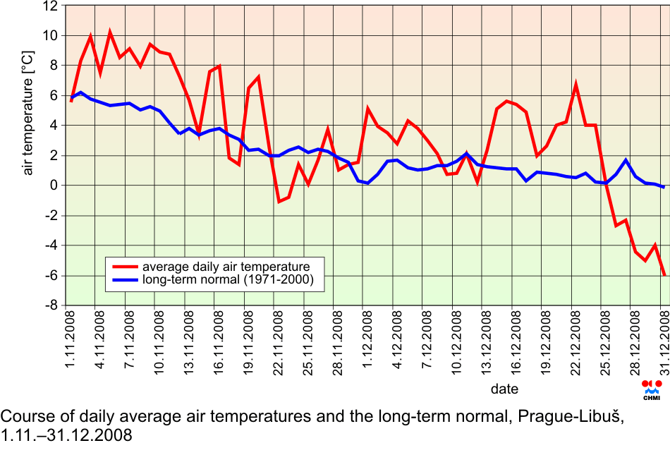
II.5 Evaluation of the smog regulation systems operation on the territory of the Czech Republic in 2008 The first two and the last two winter months of the year 2008 had above-the-normal temperatures. In January, the average temperature was 1.3 ░C with the deviation from the normal +4.1 ░C and similarly, the February average temperature reached 2.3 ░C with the deviation +3.4 ░C. November 2008 with the average temperature 4.6 ░C and December 2008 with the temperature 0.7 ░C differed from the normal by +1.9 and by +1.7 ░C respectively. According to the measurement at the station Prague-Libu┼Ī the months January and February were markedly, and November and December 2008 slightly above the normal. In the total, 76.9 % of the length of the monitored period recorded positive deviations of air temperatures form the long-term normal. The monitored year had three markedly warm periods: 18.ŌĆō21.1.2008 (maximum deviation from the normal +10.9 ░C), 27.ŌĆō29.1.2008 (maximum deviation from the normal +6.0 ░C) and 21.ŌĆō27.2.2008 (maximum deviation from the normal +11.7 ░C). Similarly, there were two cold periods: 22.ŌĆō25.2.2008 (maximum deviation from the normal ŌĆō3.1 ░C) and 26.ŌĆō31.12.2008 (maximum deviation from the normal ŌĆō5.9 ░C). The average daily air temperatures from 1.1. to 29.2.2008 and from 1.11. to 31.12.2008 and their long-term normal at the station Prague-Libu┼Ī are presented in Figs. II.5.1 and II.5.2. As for precipitation, all 4 months were weakly to moderately below the normal. The highest amount of precipitation, as compared with the long-term normal ŌĆō 37 mm ŌĆō was recorded in January 2008 and represents 90 % of the normal. As for the absolute value, the highest amount was recorded in November 2008 ŌĆō 43 mm, which represents 87 % of the normal. The lowest amount ŌĆō 27 mm ŌĆō was measured in February 2008, which represents 72 % of the long-term normal. Anticyclonic situations in JanuaryŌĆōFebruary and NovemberŌĆōDecember 2009 occurred in 28.1 % of the length of this time interval and their relative frequency for the above months was unsteady and ranged between 16.1 and 38.7 %. The highest relative frequency of the occurrence of anticyclonic situations (38.7 %) was recorded in December 2008 and the lowest one (16.1 %) in January 2008. In February 2008 the relative frequency reached 31.0 % and in November 26.7 %. The markedly warm periods in January and February 2008 were caused by the occurrence of western cyclonic situation of the type Wc (11 days) and northwest cyclonic situation of the type NWc (2 days), characteristic in winter period by the influx of relatively warm air from the central Atlantic. The markedly cold periods in November and December 2008 were caused by the anticyclone in the central Europe, type A (3 days), eastern and northeastern anticyclonic situation of the types Ea and NEa (3 days), northern cyclonic type Nc and travelling troughs of low pressure, type Bp. All the mentioned situations are characteristic by negative temperature deviations in the winter period. The average hourly SO2 concentration exceeding the alert threshold 250 ╬╝g.m-3
was registered at 13 AIM stations in 2008, out of which 4 stations were in the Kru┼Īn├® hory Mts., with the exception of January and August. The exceedance in
three subsequent hours was recorded only at the station Ostrava-Z├Īb┼Öeh with the
maximum value 959.7 ╬╝g.m-3. In the Kru┼Īn├® hory Mts. there was a contact of smoke
plume with the terrain, in the remaining cases the high concentrations were
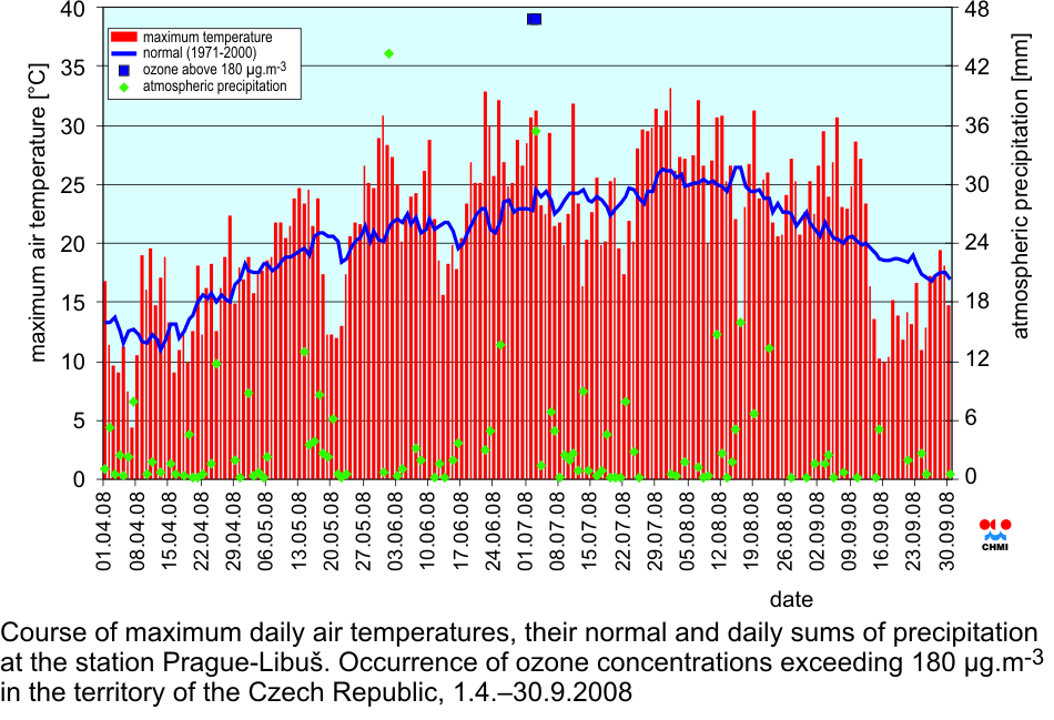
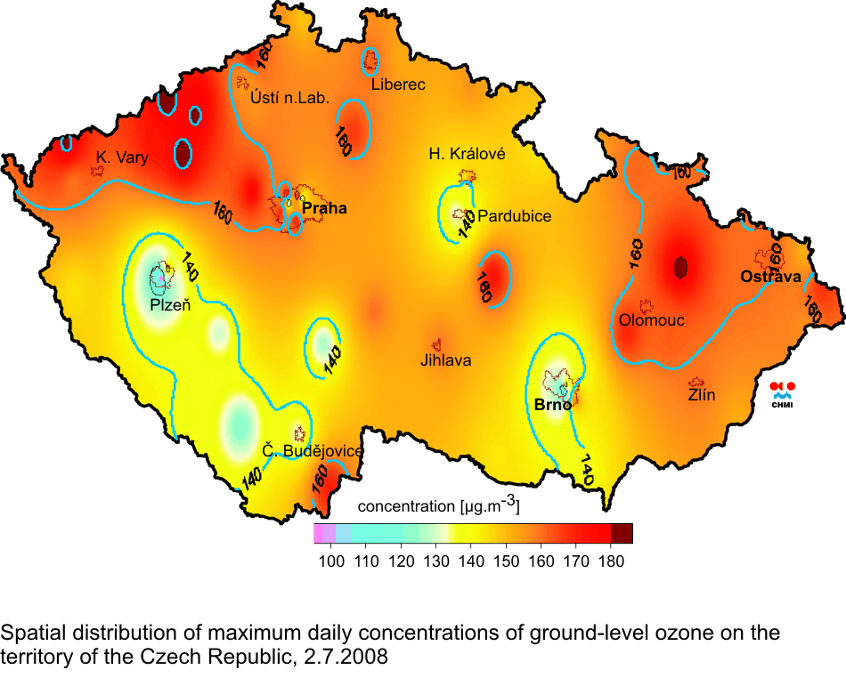
caused by local sources of air pollution. According to the analysis of maximum daily temperatures at the station Prague-Libu┼Ī the period from 1 April to 30 September 2008 was slightly above the normal with the deviation +1.3 ░C, but markedly fluctuating as for the temperature. Temperature deviations from the normal ranged in the interval from +10.7 ░C to ŌĆō13.0 ░C. The highest average monthly temperature deviation in the monitored period was recorded in June (+2.6 ░C), the lowest one in September (ŌĆō0.2 ░C); in the remaining months the deviations ranged between +0.5 ░C to +1.1 ░C. There were 14 days with the temperatures exceeding 30 ░C in the monitored period and the highest value (32.2 ░C) was measured on 1.8.2008. Meteorological conditions for the formation of tropospheric ozone from 1 April to 30 September 2008 were not much favourable, the most suitable conditions were in July when on two subsequent days the concentrations exceeding 180 ╬╝g.m-3 occurred, and on 3.7.2008 the station Rudolice v Hor├Īch measured the concentration 189 ╬╝g.m-3 (Fig. II.5.4). On 28 June 2008 there occurred the cyclone 1010 hPa near Nova Scotia, which deepened markedly while moving eastwards and on 30 June 2008 its centre with the value 985 hPa was situated west of the British Islands. On its front side there increased the influx of warm air to western and central Europe, which culminated on 2 July and partly on 3 July 2008. On 1 July the anticyclone 1020 hPa was created above central Europe with its centre above northern Poland; while moving eastwards it disintegrated. On 3 July in the afternoon the cold front accompanied by strong precipitation entered Bohemia. During the night the front moved to Moravia. On 28 and 29 June 2008 the weather was prevailingly somewhat clear, with local precipitation beyond measurements. Maximum daily temperatures in Bohemia increased from 23ŌĆō27 ░C to 27ŌĆō32 ░C, in Moravia the temperatures were approx. by 1ŌĆō2 ░C lower. On 30 June the weather in eastern Moravia and in southern Bohemia was temporarily cloudy, with local precipitation up to 20 mm, the rest of the territory had clear to somewhat clear weather. Maximum daily temperatures increased to 26ŌĆō30 ░C in Bohemia, in Moravia the temperatures were lower by about 1 ░C. On 1 and 2 July the weather in the territory of the Czech Republic was almost clear with maximum daily temperatures 26ŌĆō32 ░C in Bohemia, and in Moravia by 1ŌĆō2 ░C lower. On 3 July the weather was clear to somewhat clear (in Bohemia in the morning, in Moravia for the whole day), with maximum daily temperatures 26ŌĆō33 ░C. The cold front moved across Bohemia in the afternoon and across Moravia during the night, and it brought the precipitation of 5ŌĆō20 mm on the most of the territory of the Czech Republic, locally 30ŌĆō50 mm; the station Jev├Ł─Źko recorded 67 mm. On the following day the temperatures decreased to 20ŌĆō25 ░C in the whole republic. The increased ozone concentrations can be expected with the occurrence of high air temperatures, when the weather is clear or somewhat clear with low wind velocities. From 1 April to 30 September 2008 the station Prague-Libu┼Ī recorded 3 periods, in which for 3 and more days the afternoon temperatures reached more than 27 ░C. The overview of the periods with three or more days with temperatures exceeding 27 ░C and the respective measured maximum O3 concentrations are presented in the table II.5.2. The table shows that the most suitable conditions for the formation of tropospheric ozone were theoretically from 26.7. to 1.8.2008, but O3 concentrations reached only 173 ╬╝g.m-3. This was caused by frequent exchange of air masses above the territory of the Czech Republic (between 26.7. and 1.8.2008 four frontal disturbances moved across the territory of the Czech Republic). One of the important conditions for the occurrence of high ozone concentrations is the long stay of the air mass above a certain area. Starting from 28 June 2008 the maximum daily temperatures and ozone concentrations began to increase in the Czech Republic. On 2.7.2008 5 stations (┼Įatec, Rudolice v Hor├Īch, Most, ─īerven├Ī and P┼Öebuz) recorded the exceedance of the alert threshold limit value 180 ╬╝g.m-3; the highest value 186 ╬╝g.m-3 was measured in ┼Įatec (Fig. II.5.5). On the following day the alert threshold limit was exceeded only at the station Rudolice v Hor├Īch (189 ╬╝g.m-3), but only for 1 hour. None of the above stations recorded the concentrations above 180 ╬╝g.m-3 for three hours and more, and consequently, the conditions for the announcement of the warning signal were not fulfilled. Tab. II.5.1 The overview of O3 concentrations above 180 ╬╝g.m-3 lasting 3 hours and more Fig. II.5.1 Course of daily average air temperatures and the long-term normal, Prague-Libu┼Ī, 1.1.ŌĆō29.2.2008
Fig. II.5.2 Course of daily average air temperatures and the long-term normal, Prague-Libu┼Ī, 1.11.ŌĆō31.12.2008
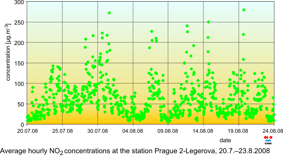
Fig. II.5.3 Average hourly NO2 concentrations at the station Prague 2-Legerova, 20.7.ŌĆō23.8.2008
Fig. II.5.4 Course of maximum daily air temperatures, their normal and daily sums of precipitation at the station Prague-Libu┼Ī. Occurrence of ozone concentrations exceeding 180 ╬╝g.m-3 in the territory of the Czech Republic, 1.4.ŌĆō30.9.2008
Fig. II.5.5 Spatial distribution of maximum daily concentrations of ground-level ozone on the territory of the Czech Republic, 2.7.2008
|