Updated: 2025-12-14 18:26 CET
Locality
| Locality: |
Wien-Taborstrasse
|
| Code: |
1TABA |
| Type of measuring programme: |
Automated measuring program |
| Locality owner: |
Magistrat der Stadt Wien |
| Abbreviation: |
T/U/R |
| Coordinates: |
48° 13´ 5.001" North latitude 16° 22´ 55.049" East longitude |
| Altitude: |
160 m |
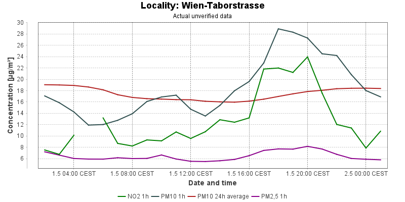
Actual measured level of air pollution
Actual unverified data
| 2025-12-13 18:00 - 19:00 CET |
|
|
34.5 |
349.4 |
|
|
21.7 |
14.0 |
16.5 |
| 2025-12-13 19:00 - 20:00 CET |
|
|
32.5 |
351.9 |
|
|
18.0 |
13.9 |
14.8 |
| 2025-12-13 20:00 - 21:00 CET |
|
|
29.4 |
353.1 |
|
|
13.2 |
13.7 |
11.4 |
| 2025-12-13 21:00 - 22:00 CET |
|
|
27.1 |
353.8 |
|
|
12.5 |
13.5 |
10.9 |
| 2025-12-13 22:00 - 23:00 CET |
|
|
26.0 |
350.0 |
|
|
12.3 |
13.4 |
10.7 |
| 2025-12-13 23:00 - 00:00 CET |
|
|
24.7 |
340.6 |
|
|
11.5 |
13.3 |
10.0 |
| 2025-12-14 00:00 - 01:00 CET |
|
|
24.4 |
335.0 |
|
|
12.0 |
13.2 |
10.3 |
| 2025-12-14 01:00 - 02:00 CET |
|
|
24.2 |
326.2 |
|
|
11.5 |
13.3 |
9.9 |
| 2025-12-14 02:00 - 03:00 CET |
|
|
22.1 |
315.0 |
|
|
11.3 |
13.2 |
9.9 |
| 2025-12-14 03:00 - 04:00 CET |
|
|
22.2 |
301.9 |
|
|
11.2 |
13.3 |
9.9 |
| 2025-12-14 04:00 - 05:00 CET |
|
|
20.8 |
288.8 |
|
|
11.7 |
13.5 |
10.3 |
| 2025-12-14 05:00 - 06:00 CET |
|
|
21.5 |
281.9 |
|
|
12.8 |
13.7 |
11.3 |
| 2025-12-14 06:00 - 07:00 CET |
|
|
21.3 |
282.5 |
|
|
13.1 |
14.0 |
11.6 |
| 2025-12-14 07:00 - 08:00 CET |
|
|
19.7 |
285.6 |
|
|
10.9 |
14.1 |
9.6 |
| 2025-12-14 08:00 - 09:00 CET |
|
|
19.8 |
290.0 |
|
|
10.1 |
14.2 |
8.8 |
| 2025-12-14 09:00 - 10:00 CET |
|
|
18.7 |
295.0 |
|
|
10.6 |
14.2 |
9.1 |
| 2025-12-14 10:00 - 11:00 CET |
|
|
|
301.9 |
|
|
10.1 |
14.0 |
8.2 |
| 2025-12-14 11:00 - 12:00 CET |
|
|
19.1 |
310.0 |
|
|
9.8 |
13.9 |
8.1 |
| 2025-12-14 12:00 - 13:00 CET |
|
|
20.6 |
319.4 |
|
|
11.1 |
13.7 |
9.0 |
| 2025-12-14 13:00 - 14:00 CET |
|
|
26.2 |
328.1 |
|
|
14.3 |
13.7 |
11.5 |
| 2025-12-14 14:00 - 15:00 CET |
|
|
27.9 |
336.2 |
|
|
17.7 |
13.6 |
14.4 |
| 2025-12-14 15:00 - 16:00 CET |
|
|
28.4 |
344.4 |
|
|
21.1 |
13.6 |
17.6 |
| 2025-12-14 16:00 - 17:00 CET |
|
|
26.8 |
353.1 |
|
|
18.7 |
13.6 |
15.2 |
| 2025-12-14 17:00 - 18:00 CET |
|
|
28.4 |
365.0 |
|
|
18.2 |
13.5 |
15.6 |
|
|
Component is not measured |
|
|
Incomplete data |
|
|
Limit exceeded |
Map of station position
Map is on page with detailed information about locality