Print Version
Introduction
Snowmelt is an integral component of the hydrologic forecasting process in many parts of the world. For flood forecasting, the spatial and temporal evolution of the snowpack, the speed at which it melts, and the impact from the water released are very important.
Here, we examine the influences of environmental conditions on snow distribution and snowpack characteristics. We will also investigate energy exchanges between the snow and atmosphere, and how those exchanges affect the rate of snowmelt. Finally, the fate of snowmelt water after it reaches the ground will be discussed.
In this module, you will learn to:
- Describe the development and evolution of snowpack:
- Explain the influences of terrain, wind, vegetation, and temperature.
- Describe how sublimation affects snowpack.
- Describe the process of snow metamorphism.
- Explain SLR and SWE.
- Describe why and how snow energy exchanges are important.
- Describe the processes that occur before and during melting:
- Explain the importance of latent heat exchange.
- Describe what is necessary for rapid melting.
- Explain the importance of rainfall on the snowmelt process.
- Describe the fate of melt water from snow:
- Describe how water can move through the snowpack.
- Explain what happens when melt water reaches the ground surface.
Snow Distribution
The distribution of snowfall can vary significantly across short distances, especially in the presence of abrupt changes in terrain or vegetation. Understanding spatial and temporal differences in snow accumulation is important to making any hydrologic forecast where snowmelt is concerned, especially for regions with sparse snow depth measurements.
Vegetation
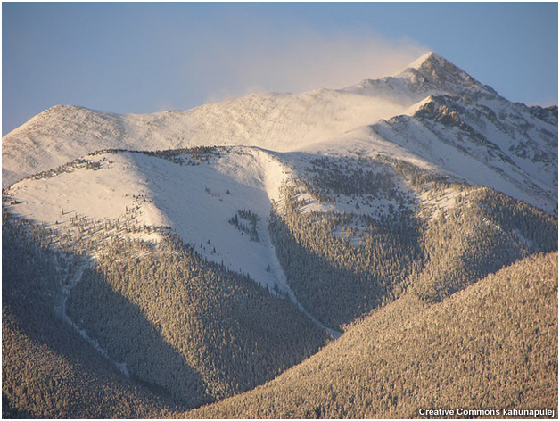
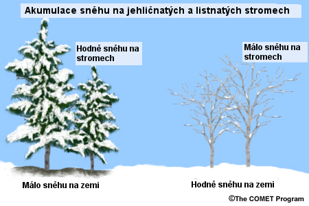
Terrain features and vegetation can have a large influence on how the snow accumulates on the ground, through both the direct interception of snowfall and through locally influencing the wind speed and direction.
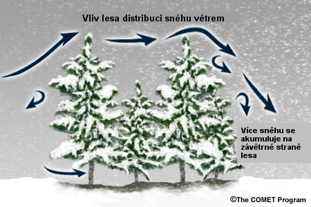
Two main phenomena govern the amount of snow accumulating on the ground within a forested area. First, turbulent air flow may lead to variations in snow loading on the ground, with relatively greater accumulations typical downwind of forested areas.
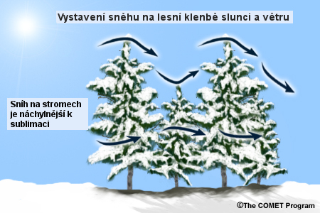
The second phenomenon is the direct interception of snow by vegetation. Snow that settles onto vegetation is exposed to more wind and sun than snow on the ground and has a higher surface area to mass ratio, thereby making it more prone to sublimation and/or melting.
The amount of canopy snow possible is directly related to the types of trees. Coniferous trees are relatively efficient snow interceptors. Deciduous trees, being leafless for the majority of the snowy season, are not.
Sublimation losses from snow in coniferous tree canopies can be very significant, up to about 40% of the seasonal snow fall in some regions. However, the increased sublimation from snow in canopies can be offset by the shading that the trees create. An Alaskan study showed that vegetation reduces sublimation at the ground by about 60%.
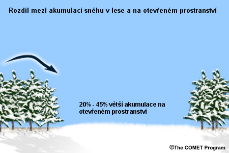
Interception of snow by trees and subsequent sublimation are major factors contributing to the difference in accumulation between clear areas and densely vegetated ones, but they are not the only factors. Clearings in forest may see relatively greater accumulations of snow, ranging from 20-45% more snow.
The size of clearing is a critical factor. If the horizontal distance across the clearing is considerably greater than the height of the trees, the clearing may become windswept. This windblown snow can end up accumulating downwind in the forest.
Open Environments and Blowing Snow
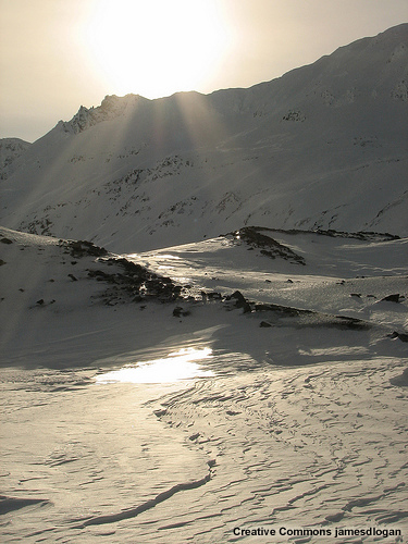
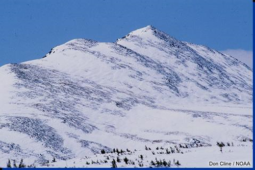
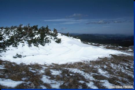
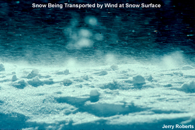
For areas lacking significant vegetation, the effects of microscale differences may produce wide variations in accumulation patterns, as shown in the photographs below.
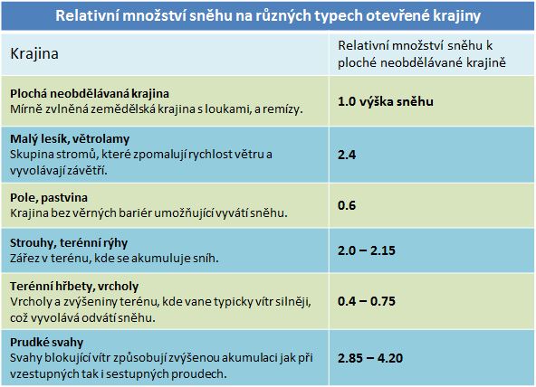
Lets take a look at some relative accumulation values for open environments. These values are normalized to what is termed, "level fallow plains", or relatively flat ground that has not been planted, plowed or harvested in a long time. For instance, in a tree cluster where the wind slows down and the accumulation would be a little higher, we could get maybe 2.4 times the accumulation that would occur on level fallow plains. The table below summarizes the relative accumulations for various landscape types.
Check Your Understanding: Vegetation
Deciduous trees do not cause any increase in snow accumulation on the ground below and/or immediately downwind. (Choose the best answer)
The correct answer is False.
Although deciduous trees are not nearly as efficient in intercepting snowfall as coniferous trees, they still capture some snow on their branches. Their presence also slows the wind through increased friction and turbulence, resulting in higher snow accumulations around and immediately downwind, compared to surrounding clear areas.
Blowing snow is more common across open environments. There are three different types of blowing snow, and the classification is correlated strongly to windspeed. The table below summarizes the conditions of blowing snow.
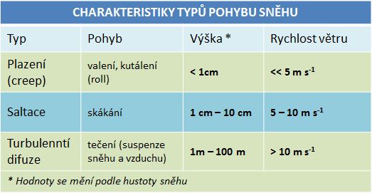
Snow transport rates are approximately proportional to the 10 meter windspeed cubed. This means that a doubling in wind speed would cause the transport rate to go up by 8 times. Of course, other characteristics, such as snow density or snowpack hardness, will influence this rate. In general, older, wind-hardened snow may require more than twice the wind speed for transport to begin.
Snowpack Characteristics
Blowing snow can have a significant impact on the character of the snowpack as well.
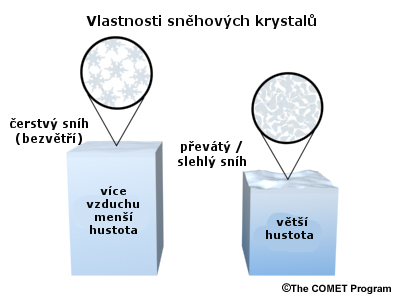
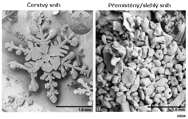
In light wind conditions, fresh snow generally consists of pristine crystals with a lot of air space between them. When snow has been transported by wind and drifting occurs, the ice crystals break and the snow takes on a more rounded shape. This results in more closely packed snow particles, and thus an inherently more dense snowpack.
Under an electron microscope, the differences are even more pronounced:
When discussing density, we tend to think in terms of mass per volume, with a typical snow density being 0.1 g/cm3. That makes snow one tenth as dense as water because it is composed of both water and air. The other main factor that determines snowpack density is the amount of liquid present.
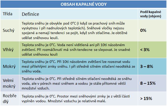
Understanding the water equivalent of snow is very important for the hydrologic forecaster. Dry snow has 0% liquid water content and doesnt stick together. Water accounts for a few percent of the volume of moist snow. The table below shows the classification of snow by liquid water content and visible and physical behavior.
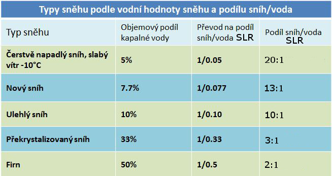
Snow Water Equivalent and Snow-to-Liquid Ratio
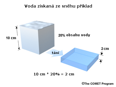
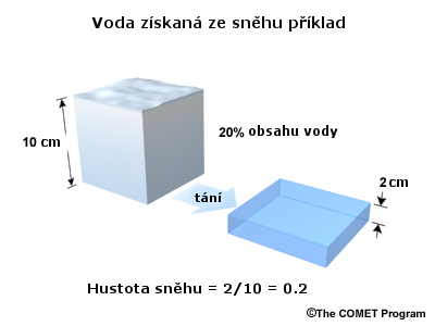
When talking about snowpack, hydrologists usually express density as the depth of the pack versus the depth of the water that would be produced if the snow were melted. The depth of water produced if a snow cover is completely melted on a horizontal surface is known as the snow water equivalent or SWE. For example, 10 depth units of snow with a liquid equivalent of 20% will melt and become 2 units deep.
This can also be expressed as a unitless ratio of snow depth to liquid depth, or the snow-to-liquid ratio (SLR). In the example above, there are 10 depth units of snowfall compared to 2 depth units of liquid. This means the SLR is 5:1.
Here are some examples of typical snow-to-liquid ratios for various situations. Fresh fallen snow with generally calm winds, and temperatures below freezing has a water equivalent content of about 5%, which comes out to an SLR of 20 to 1. In some cases, this could actually be a lot higher than 20 to 1. We can see 40, 60, or even 80 to one ratios at times. As snow starts to settle, warm, blow, or a combination of the three, the SLR decreases as the snow water equivalent content increases. This is shown for several conditions in the chart below.
SLR Calculation
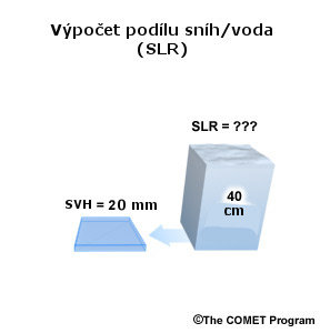
The volume of snow shown on the right side in the image above is 40 units deep. We melt the snow and it is now 2 units deep. What is the snow-to-liquid ratio? (Choose the best answer)
The correct answer is d.
40 depth units to 2 depth units reduces to 20:1.
SLR Calculation 2
It is the first snow of the season, and 50 units of snow just fell over your area. The SLR has been reported to be 5:1. How much liquid water would be present if we melted all the snow? (Choose the best answer)
The correct answer is b.
Temperature
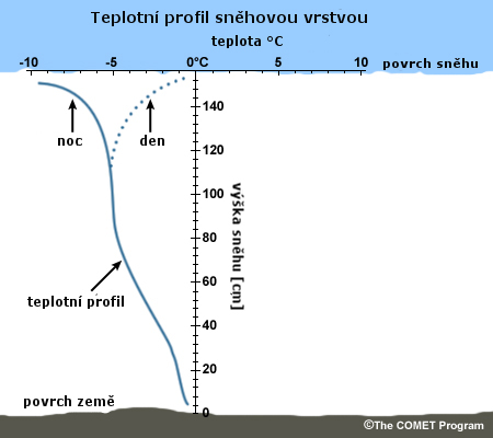
The temperature profile of a snowpack is very important to consider when assessing what the melting characteristics might be. The physical processes that occur within the snowpack are highly dependent on whether a temperature gradient exists between the top and bottom of the snowpack.
A temperature gradient is usually present in a snowpack, due to the relative geothermal warmth provided by contact with the ground at the bottom compared to the relative cold air temperatures at the top. The temperature at the top of the snowpack frequently fluctuates daily due to the changing solar input. The middle portion of the snowpack may warm when melt water or rainwater from above refreezes and releases latent heat.
An isothermal situation occurs if a temperature gradient does not exist through the snowpack. If the snowpack is isothermal and at or near 0°C, then the snow is deemed to be ripe and can be subject to rapid melting.
Snow Metamorphism
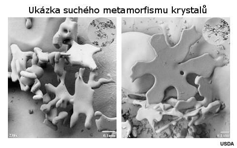
There are two types of snow metamorphism: dry and wet. In the dry type, no liquid water is present and temperatures are generally below freezing.
There are two types of dry snow metamorphism. First is equilibrium, or sintering, which occurs with small snowpack temperature gradients. Changes in the crystal structure often result in more bonding between the crystals. As water vapor gets deposited onto the crystals, the hollows are filled in and the points become more round. In some cases, the deposition and resulting change of crystal shape are so extreme that one can no longer identify the original crystal structure and character. The new, more rounded shapes result in a greater snowpack density, and therefore, a greater SWE per depth unit. This is the most important type of dry metamorphism for snow hydrology.
The other type of dry metamorphism is kinetic growth, which occurs when snowpack temperature gradients are greater than 10°C m-1. New crystal structures are often poorly bonded and can actually lower the density of the snowpack.
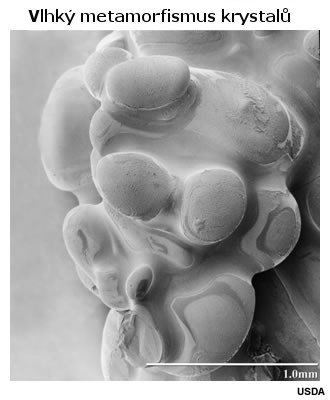
In the wet type of metamorphism, temperatures are near or at the freezing point. Liquid water is present and the small snow grains are destroyed preferentially while the large grains become rounded via melting. It becomes difficult to identify the original crystal structure. Melting and refreezing results in large bonded grain clusters, as shown in the photograph below. SWE per depth unit can increase significantly during times of wet snow metamorphism.
Snow Energy Exchanges
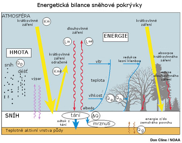
In diagram form, the main factors contributing to the snow-energy exchange might look something like the diagram below. The K terms represent the solar input, both incoming and outgoing. The L terms are the longwave radiation, both incoming and outgoing. Turbulent transfer of both latent and sensible heat are shown as Qe and Qh. Ground conduction, Qg, occurs at the bottom of the snowpack. And finally, there is advected heat, Qp, that occurs during rain on snow situations.
Solar Input and Albedo
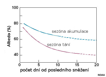
The albedo of a surface is the ratio of reflected solar radiation to incident solar radiation upon it. The albedo of snow can change drastically, depending on several conditions. When snow is fresh and crystals are pristine, the albedo may be as high as 90%. In general, albedo values are at least 80% for fresh snow. As snow ages, its crystal structure becomes more rounded, due to wet or dry metamorphism or from becoming windblown. These factors effectively reduce the snows ability to reflect incoming solar radiation. The snowpack may also become less reflective due to particulate accumulation on its surface. The sun angle is also important to consider. The sun angle is relatively low during the accumulation season. Temperatures then are usually lower and snow albedo tends to change much less quickly than in melt season, when incoming solar radiation is more intense and temperature changes more over the course of a day.
Because of all these factors, snow albedo typically decreases dramatically for a few days after a snowfall. After that, albedo tends to level off at about 60% during accumulation season and 40% during melt season. The graph below shows how albedo changes for both seasons as a function of time since the previous snow fall.
Latent Heat
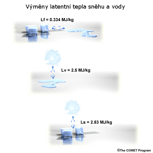
Latent heat exchange is a very important consideration for determining whether snow is going to melt. Latent heat is the hidden heat that is exchanged with the surrounding environment in the event of a phase change of water. For example, the latent heat of fusion, or the energy required to change liquid water to ice or vice versa, is about one-third of a megajoule per kilogram. The latent heat of vaporization, or the energy required to change water between the liquid and gas phases, and latent heat of sublimation, or energy required to change from a solid directly to gas or vice versa, are about eight times higher than the latent heat of fusion, as shown in the figure below.
This means that when snow directly sublimates into the atmosphere, or atmospheric water vapor directly deposits down into the snowpack, a dramatic change in the temperature at the snow surface will occur.
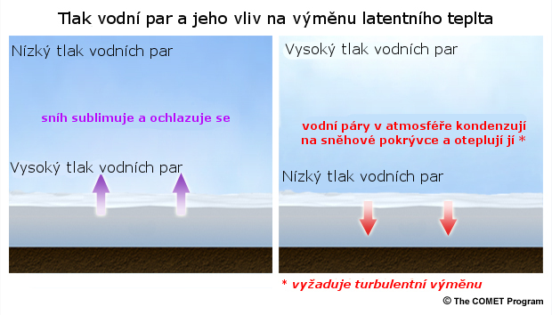
An important factor to consider in latent heat exchange is the atmospheric vapor pressure, which can be approximated by the dew point temperature.
When vapor pressure decreases with height in the atmosphere, moisture from the snow will be diffused to the atmosphere above. In this situation, moisture sublimates from the snow, latent heat is lost from the snow, and the snow stays cold, even if the air temperatures are rather warm.
When vapor pressure increases with height in the atmosphere, moisture from the atmosphere above will be deposited to the snows surface. In this situation, latent heat is gained by the snow, and the snow surface will warm. This warming may start the melting process within the snowpack. To achieve melting in this manner requires winds strong enough to induce turbulent transfer, so that warmth and higher humidity from above continually come into contact with the snow surface.
Turbulent Transfer
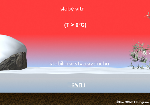
When winds are calm, there is minimal turbulent transfer at the snow surface. This is because the cooling caused by sublimation creates a stable cold layer just above the snows surface. Without wind, that stable cold layer does not break up, even if air temperatures are significantly warmer than 0°C. This effect is most pronounced in shaded areas.
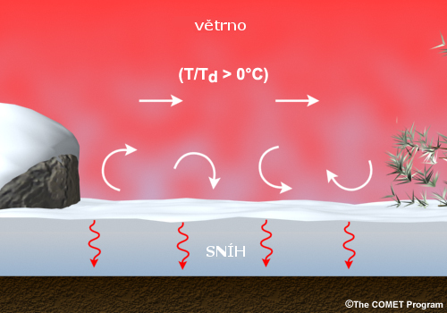
Increased winds create turbulence as they blow across the surface of the snow. This mixes the sublimatively cooled air just near the snows surface with warmer air aloft, effectively bringing warmer temperatures to the snowpack. In cases in which the atmospheric vapor pressure increases with height, as mentioned above, this process is enhanced as moisture is preferentially gained by the snowpack. Large turbulent transfer of warm, moist air from above dominates the energy transfer on cloudy days and in shaded locations. A very intense snowmelt requires high winds with temperatures and dew points that are both above freezing.
Advection
Rain on snow situations are often seen as a "worst case scenario" by forecasters concerned about rapid snowmelt. However, rain falling onto snow does not always cause rapid warming of the snow, or even warming at all. Lets imagine a situation in which rain with a temperature of 10°C is falling at a rate of 10 mm per day. This rain is warm enough that it does not freeze as it trickles down through the snowpack. As the rain moves through the snowpack, it will impart small amounts of heat energy to the snow.
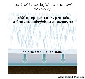
The heat imparted by this warm rainfall would be about 420 kJ m-2 per day. This amounts to about 5 W m-2, which is at least an order of magnitude less than the solar energy absorbed on a sunny winter day with a low sun angle and fresh snow.
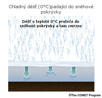
Now lets imagine a situation in which cold rain, with a temperature between 0°C and 1°C, is falling. As this cold rain trickles down into the snowpack, it loses heat to the snow and begins to freeze, forming areas of ice.
Complete the following question to find out how this formation of ice will influence the possibility of snowmelt occurring.
Check Your Understanding: Advection
The temperature of the snowpack will _____ as a result of this cold rain that begins to freeze. (Choose the best answer)
The correct answer is a.
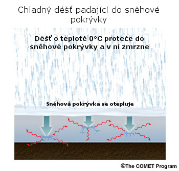
When ice begins to form, latent heat is released to the surrounding snowpack, causing the overall temperature to rise.
How much will the temperature of the pack rise from this cold rain? This time, the same 10 mm of rain at 0°C freezes and releases its latent heat of fusion within the snowpack. Let's assume that the rain is uniformly distributed over a one meter snow depth that has a density of 340 kg m-3 and initial temperature of –5°C. Upon freezing, 3350 kJ of heat would be released to the pack, raising the average temperature of the snowpack from –5°C to 0°C!
The key finding in the above examples is that while rainfall might not be the major contributor to melting the snow, rainfall that freezes within the snow is very important for ripening the snow and making it more prone to melting.
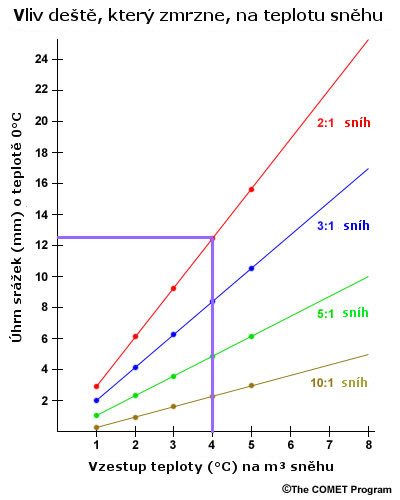
So, whats the relationship between the amount of rain that freezes in the snowpack and the amount of warming that occurs? The graph below shows the relationship between the amount of rain that freezes within a snowpack and the resulting warming for four different snow-to-liquid ratios, varying from a dense 2:1 ratio snow to a more "fluffy" 10:1 ratio snow. Dense snow requires much more rain to effect a specific rise in temperature. For example, lets determine what amount of rainfall would cause a 4 degree warming of a "fluffy" snowpack that has a SLR of 10:1.
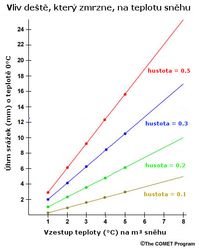
Reading upward from 4 degrees to the intersection with the 10:1 ratio line and then finding the appropriate rainfall amount to the left, we see that about 2 mm of rain would cause this amount of warming.
Check Your Understanding: Advection 2
Using the same graphic above, what amount of rainfall would cause the same 4°C warming for the more dense 2:1 Snow? (Choose the best answer)
The correct answer is d.
In summary, snowpack can gain or lose heat through the various forms of energy exchange discussed above. Where snowmelt is concerned, the greatest ripening and/or melting is usually possible on relatively warm, humid (probably cloudy), and windy days.
Water Flow and Snowpack
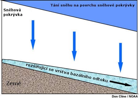
Melt water can move through snow at a wide range of velocities, from 2 cm per minute up to 60 cm per minute. The speed depends on several factors, including the internal snowpack structure, condition of the snowpack prior to the introduction of water, and the amount of water available at the snow surface.
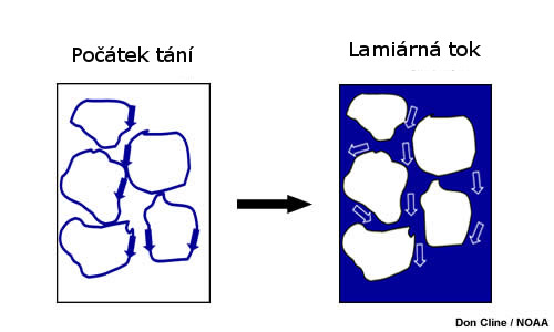
At the melting temperature, a thin film of water surrounds each snow grain. This film provides a pathway for additional meltwater to follow. Once the pores between the snow grains are filled with water, laminar flow can occur, which is a very efficient method of draining the snowpack.
Dye studies reveal that water moves through snowpack in other such preferential pathways, or macropores. These macropores can be present in both the horizontal and vertical. Horizontal pathways tend to form when impermeable ice lenses force the water to either pond or to move laterally until it finds another vertical pathway to follow to the bottom of the snowpack.
Measurements taken at Niwot Ridge, Colorado, USA in May of 1995 quantitatively show how liquid water can be transmitted through a snowpack.
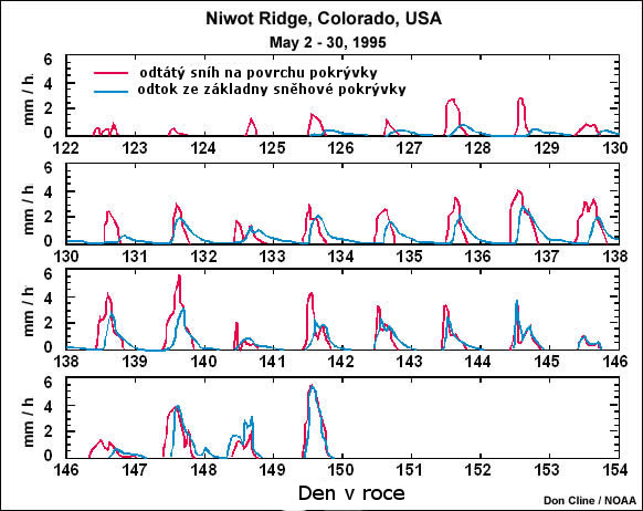
Early in May melting was occurring at the snowpack surface (red), but no water was draining from the bottom of the pack (blue). This is because the water was still remaining within the snowpack and sometimes refreezing there. As days went by, water did begin to emerge onto the ground surface at the bottom of the snowpack. By about the end of the month, significant snowmelt had occurred, and nearly all of the melted snow from the top was able to percolate downward through the pack onto the surface. We can see that by day 149, the water at the surface of the snowpack and the water that was measured coming out of the bottom had nearly identical magnitudes and timing.
Fate of Snowmelt: Impact of Ground Conditions
When water trickles down through a snowpack and reaches the ground below, its fate is determined by the conditions of the ground and the grounds surface. These are important considerations when forecasting runoff and possible flooding.
If the ground is unfrozen and unsaturated, it should be able to absorb the water quite easily as long as the snowmelt rate is less than the infiltration rate of the soil. In this case, the snowmelt would behave a lot like rainfall.
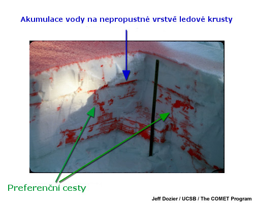
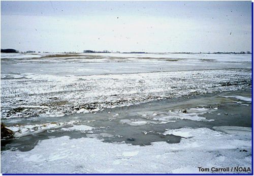
If the water trickling down through the snowpack encounters frozen soil, there is a possibility that water will pond and possibly refreeze at the soil surface, further impeding any infiltration of water into the soil in that region. In rapid snowmelt situations, this can cause significant flooding.
The photograph shows the consequences of melt water that refreezes at the soil surface, known as basal ice.
Sloped surfaces can cause more complications. Pore spaces downslope are continually eroded not only by meltwater from directly above but also from meltwater that originates laterally upslope. This creates a greater volume of flow as water moves downslope underneath the snowpack, which can eventually erode the snowpack from beneath as seen in the image below.
Surface slope is just one of many factors to examine when considering how snowmelt will be absorbed and channeled by the land. The other typical rainfall-runoff factors presented in the Runoff Processes: International Edition module apply to snowmelt situations and would complement any further examination of the fate of snowmelt water.
Summary
Snow Distribution
- Two main factors influence how snow accumulates on the ground: terrain and vegetation.
- Vegetation influences snow accumulation through altering the wind and through sublimation.
- Snow that is directly intercepted by foliage is more exposed to air, and thus more susceptible to sublimation.
- Areas of tall vegetation serve to slow down the wind, creating higher ground accumulations immediately downwind of trees and within clearings in forested areas.
- Clearings between areas of trees can become windswept if the horizontal distance is much greater than the height of the trees themselves.
- In open environments, areas that are exposed to higher winds, such as very flat surfaces, surfaces lacking vegetation, and ridges and/or hilltops, become windswept and have less accumulation.
Snowpack Characteristics
- Fresh snow generally consists of pristine crystals with a great amount of air between them. As snow ages, crystals become more rounded due to melting, sublimation and transport by winds. This causes settling and makes the snowpack denser.
- The snow water equivalent, or SWE, is the amount of liquid that results from melting the snow.
- The snow-to-liquid ratio, or SLR, is the SWE expressed as a ratio of the height of the snowpack compared to the height of the liquid produced when it is melted.
- Both SLR and SWE are gauges of the density of a snowpack. SLR values typically range from around 20:1 for fresh snow that fell in temperatures well below freezing, to 2:1 for snow that has been windblown, aged and is near 0°C.
- The temperature of snowpack usually changes from the top to the bottom.
- Temperatures at the bottom of the pack are relatively warm, due to contact with the ground.
- Temperatures at the top vary between cold during the night and warmer during the day, though it may still be much colder than the bottom, when cold airmasses are in place.
- There are two types of snow metamorphism: dry and wet.
- During dry metamorphism, no liquid water is present and temperatures are usually well below freezing. SWE may be increased or decreased, depending on circumstances.
- During wet metamorphism, the temperature is near the freezing point and liquid water is present. Melting and refreezing results in significantly higher SWEs.
Snow Energy Exchanges
The energy budget of snowpack and its surroundings consists mainly of the following: incoming and reflected solar radiation, incident and emitted longwave radiation, turbulent transfer of latent and sensible heat, ground conduction, and heat that is advected during rainfall.
- The snow albedo, or ratio of reflected solar radiation to incident solar radiation, decreases as snow ages, causing the snowpack to absorb more solar energy over time.
- Latent heat is the energy that is exchanged with the surrounding environment during a phase change of water.
- The latent heat of sublimation is about 8 times greater than the latent heat of fusion.
- The atmospheric vapor pressure above the snowpack can greatly affect how much sublimation occurs.
- If vapor pressure decreases with height in the atmosphere, snow will sublimate, causing latent heat to be released from the pack.
- If vapor pressure increases with height in the atmosphere, moisture will deposit onto the snowpack, and latent heat will be gained by the pack.
- Significant warming of the snowpack via deposition and subsequent latent heat release usually requires strong winds that induce turbulent transfer.
- When winds are calm, turbulent transfer is at a minimum, and any air that is sublimatively cooled near the snowpack surface remains near the surface.
- When winds are strong, turbulent transfer occurs, and mixes any sublimatively cooled air near the snowpack surface with warmer air aloft. This can cause the melting process to begin, especially if winds are strong and vapor pressure increases with height in the atmosphere.
- Rain falling on snowpack will impart some heat upon it. The amount of heat imparted depends on the temperature of the rain and any phase change that occurs.
- A rainfall 'warm' enough that it does not freeze as it trickles through the snowpack will impart small amounts of heat as it passes through the pack.
- A rainfall 'cool' enough that it freezes as it trickles through the pack will cause significantly more heat to be gained by the snowpack, as latent heat will be released to the snow during freezing.
- The amount of warming that occurs via rainfall freezing within the snowpack depends on the initial SLR, or density, of the snowpack.
Water Flow and Snowpack
- Water moves through snowpack most effectively once the pore spaces between snow grains are saturated, or filled with water.
- Preferential pathways for water moving through snowpack, or macropores, form in both the horizontal and vertical.
- Horizontal pathways tend to form when ice lenses force water to move around them.
- There is often a delay between snowmelt initiation within a pack and the meltwater exiting at the bottom of the snowpack. This delay may be several days or more, depending on the season.
Fate of Snowmelt
- When soil is unfrozen and unsaturated, meltwater will be absorbed as long as the snowmelt rate is less than the infiltration rate.
- When soil is frozen, infiltration of meltwater is impeded. This can cause ponding and possible refreezing of meltwater onto the ground. In rapid snowmelt situations, this may cause flooding.
- More meltwater will accumulate downslope along a hill or sloped surface.
You have reached the end of this module. Please take a moment to provide us with your feedback by completing a brief survey: Begin Survey