Information about air quality in the Czech Republic
Current overview of data from automated stations (non-verified data)
Updated: 2024-05-08 01:30 CEST
Locality
| Locality: |
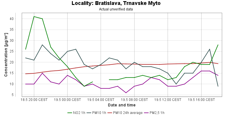
Bratislava, Trnavske Myto
|
| Code: |
GBRTA |
| Type of measuring programme: |
Automated measuring program |
| Locality owner: |
Slovak Hydrometeorological Institute |
| Abbreviation: |
T/U/- |
| Coordinates: |
48° 9´ 31.001" North latitude 17° 7´ 44.001" East longitude |
| Altitude: |
136 m |
Actual measured level of air pollution
Actual unverified data
| 2024-05-07 01:00 - 02:00 CEST |
|
|
2.0 |
193.4 |
|
|
4.0 |
17.4 |
2.0 |
| 2024-05-07 02:00 - 03:00 CEST |
|
|
2.0 |
184.2 |
|
|
2.0 |
17.1 |
|
| 2024-05-07 03:00 - 04:00 CEST |
|
|
1.0 |
176.2 |
|
|
1.0 |
17.0 |
|
| 2024-05-07 04:00 - 05:00 CEST |
|
|
2.0 |
167.9 |
|
|
4.0 |
16.7 |
|
| 2024-05-07 05:00 - 06:00 CEST |
|
|
9.0 |
156.1 |
|
|
4.0 |
16.5 |
|
| 2024-05-07 06:00 - 07:00 CEST |
|
|
|
147.6 |
|
|
4.0 |
15.8 |
|
| 2024-05-07 07:00 - 08:00 CEST |
|
|
31.0 |
158.9 |
|
|
7.0 |
15.3 |
|
| 2024-05-07 08:00 - 09:00 CEST |
|
|
32.0 |
172.8 |
|
|
11.0 |
14.6 |
4.0 |
| 2024-05-07 09:00 - 10:00 CEST |
|
|
24.0 |
183.9 |
|
|
6.0 |
13.8 |
2.0 |
| 2024-05-07 10:00 - 11:00 CEST |
|
|
29.0 |
191.7 |
|
|
3.0 |
13.0 |
2.0 |
| 2024-05-07 11:00 - 12:00 CEST |
|
|
24.0 |
204.4 |
|
|
9.0 |
12.6 |
1.0 |
| 2024-05-07 12:00 - 13:00 CEST |
|
|
25.0 |
215.1 |
|
|
11.0 |
12.8 |
4.0 |
| 2024-05-07 13:00 - 14:00 CEST |
|
|
22.0 |
224.1 |
|
|
7.0 |
11.9 |
4.0 |
| 2024-05-07 14:00 - 15:00 CEST |
|
|
30.0 |
230.0 |
|
|
2.0 |
10.9 |
1.0 |
| 2024-05-07 15:00 - 16:00 CEST |
|
|
31.0 |
224.3 |
|
|
17.0 |
11.1 |
3.0 |
| 2024-05-07 16:00 - 17:00 CEST |
|
|
41.0 |
234.0 |
|
|
14.0 |
10.8 |
5.0 |
| 2024-05-07 17:00 - 18:00 CEST |
|
|
42.0 |
242.9 |
|
|
5.0 |
10.1 |
7.0 |
| 2024-05-07 18:00 - 19:00 CEST |
|
|
39.0 |
248.0 |
|
|
9.0 |
9.5 |
10.0 |
| 2024-05-07 19:00 - 20:00 CEST |
|
|
27.0 |
250.9 |
|
|
22.0 |
9.7 |
12.0 |
| 2024-05-07 20:00 - 21:00 CEST |
|
|
34.0 |
259.9 |
|
|
20.0 |
9.8 |
12.0 |
| 2024-05-07 21:00 - 22:00 CEST |
|
|
29.0 |
265.6 |
|
|
21.0 |
9.8 |
13.0 |
| 2024-05-07 22:00 - 23:00 CEST |
|
|
17.0 |
265.5 |
|
|
18.0 |
9.7 |
8.0 |
| 2024-05-07 23:00 - 00:00 CEST |
|
|
18.0 |
261.2 |
|
|
15.0 |
9.5 |
8.0 |
| 2024-05-08 00:00 - 01:00 CEST |
|
|
10.0 |
245.4 |
|
|
18.0 |
9.8 |
8.0 |
|
|
Component is not measured |
|
|
Incomplete data |
|
|
Limit exceeded |
Map of station position
Map is on page with detailed information about locality
 ISKO
ISKO