Information about air quality in the Czech Republic
Current overview of data from automated stations (non-verified data)
Updated: 2024-05-08 03:29 CEST
Locality
| Locality: |
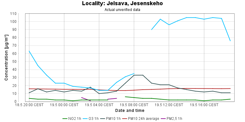
Jelsava, Jesenskeho
|
| Code: |
FJEJA |
| Type of measuring programme: |
Automated measuring program |
| Locality owner: |
Slovak Hydrometeorological Institute |
| Abbreviation: |
B/S/- |
| Coordinates: |
48° 37´ 49.020" North latitude 20° 14´ 22.846" East longitude |
| Altitude: |
0 m |
Actual measured level of air pollution
Actual unverified data
| 2024-05-07 03:00 - 04:00 CEST |
|
|
3.0 |
|
43.0 |
56.8 |
15.0 |
16.7 |
|
| 2024-05-07 04:00 - 05:00 CEST |
|
|
3.0 |
|
41.0 |
52.8 |
21.0 |
16.6 |
6.0 |
| 2024-05-07 05:00 - 06:00 CEST |
|
|
3.0 |
|
35.0 |
48.2 |
23.0 |
16.7 |
6.0 |
| 2024-05-07 06:00 - 07:00 CEST |
|
|
10.0 |
|
27.0 |
43.5 |
21.0 |
16.8 |
|
| 2024-05-07 07:00 - 08:00 CEST |
|
|
17.0 |
|
25.0 |
39.6 |
22.0 |
16.9 |
14.0 |
| 2024-05-07 08:00 - 09:00 CEST |
|
|
|
|
46.0 |
39.0 |
24.0 |
16.7 |
12.0 |
| 2024-05-07 09:00 - 10:00 CEST |
|
|
3.0 |
|
74.0 |
41.8 |
14.0 |
16.5 |
|
| 2024-05-07 10:00 - 11:00 CEST |
|
|
3.0 |
|
66.0 |
44.6 |
8.0 |
16.1 |
|
| 2024-05-07 11:00 - 12:00 CEST |
|
|
8.0 |
|
|
44.9 |
10.0 |
15.9 |
|
| 2024-05-07 12:00 - 13:00 CEST |
|
|
9.0 |
|
40.0 |
44.7 |
13.0 |
15.8 |
|
| 2024-05-07 13:00 - 14:00 CEST |
|
|
5.0 |
|
43.0 |
45.9 |
12.0 |
15.8 |
|
| 2024-05-07 14:00 - 15:00 CEST |
|
|
5.0 |
|
43.0 |
48.1 |
6.0 |
15.6 |
|
| 2024-05-07 15:00 - 16:00 CEST |
|
|
|
|
|
|
|
15.7 |
|
| 2024-05-07 16:00 - 17:00 CEST |
|
|
3.0 |
|
58.0 |
|
6.0 |
15.3 |
|
| 2024-05-07 17:00 - 18:00 CEST |
|
|
3.0 |
|
63.0 |
|
8.0 |
15.1 |
|
| 2024-05-07 18:00 - 19:00 CEST |
|
|
3.0 |
|
67.0 |
|
12.0 |
15.2 |
|
| 2024-05-07 19:00 - 20:00 CEST |
|
|
3.0 |
|
61.0 |
53.6 |
13.0 |
15.3 |
|
| 2024-05-07 20:00 - 21:00 CEST |
|
|
3.0 |
|
63.0 |
56.9 |
13.0 |
15.1 |
|
| 2024-05-07 21:00 - 22:00 CEST |
|
|
3.0 |
|
73.0 |
61.1 |
13.0 |
15.0 |
|
| 2024-05-07 22:00 - 23:00 CEST |
|
|
3.0 |
|
75.0 |
65.7 |
12.0 |
14.8 |
|
| 2024-05-07 23:00 - 00:00 CEST |
|
|
2.0 |
|
83.0 |
67.9 |
11.0 |
14.2 |
|
| 2024-05-08 00:00 - 01:00 CEST |
|
|
2.0 |
|
86.0 |
71.4 |
9.0 |
13.8 |
|
| 2024-05-08 01:00 - 02:00 CEST |
|
|
2.0 |
|
87.0 |
74.4 |
10.0 |
13.5 |
|
| 2024-05-08 02:00 - 03:00 CEST |
|
|
2.0 |
|
85.0 |
76.6 |
9.0 |
13.3 |
|
|
|
Component is not measured |
|
|
Incomplete data |
|
|
Limit exceeded |
Map of station position
Map is on page with detailed information about locality
 ISKO
ISKO